Batch Scheduling
Copyright
© 2009 Automated Business Solutions, Inc.
Batch scheduling refers to a scheduling process whereby the scheduler selects all
unscheduled trips or a subset of unscheduled trips and uses an automated
scheduling tool to insert the selected trips into existing vehicle schedules in
one batch run. Interactive scheduling is the process where the scheduler selects
one trip at a time and using an automated scheduling tool inserts the trip into
the “best vehicle” option – one that generally add the least vehicle miles to
any schedule while maintaining existing on-time performance.
The PtMS Interactive Scheduler (PtMSIS) supports both batch scheduling
and interactive scheduling. What makes
PtMSIS unique is how seamlessly users can move from one mode to the other when
scheduling. This article will describe
the basics of PtMSIS batch scheduling.
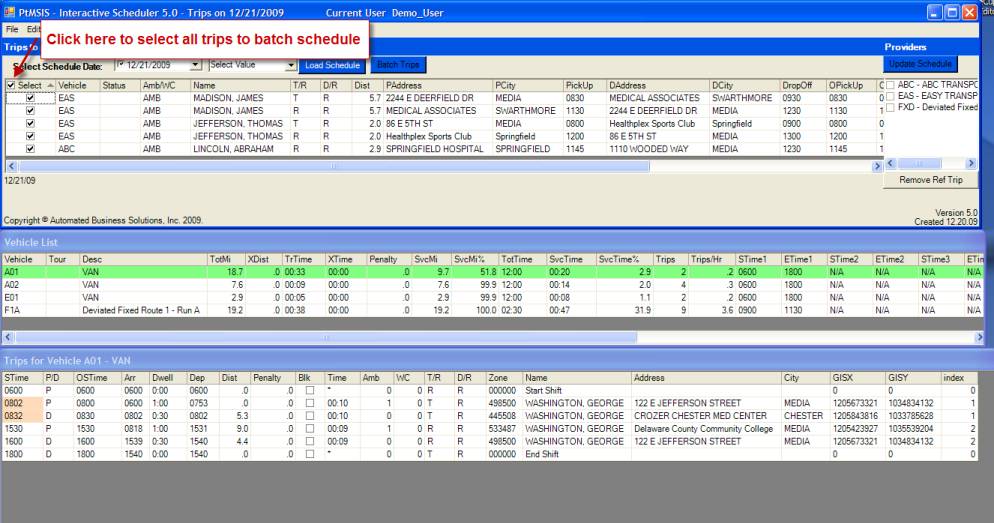
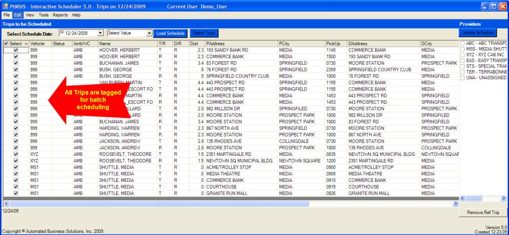
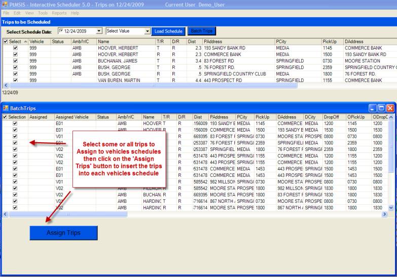
Select Unscheduled Trips to Batch
The user must first select
the trips to batch schedule. All
scheduled trips can be selected or the user can divide the unscheduled trips
into sets for batching (e.g. morning vs. afternoon trips, all trips for one
destination, etc.).
Run the Batch
The user clicks on the Batch
Trips button to schedule the selected trips in a few seconds. A hundred trips can be batched in a few
seconds. There is no limit on the number of trip records you can include in a
batch scheduling run.
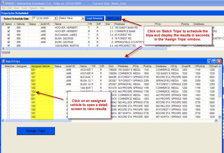
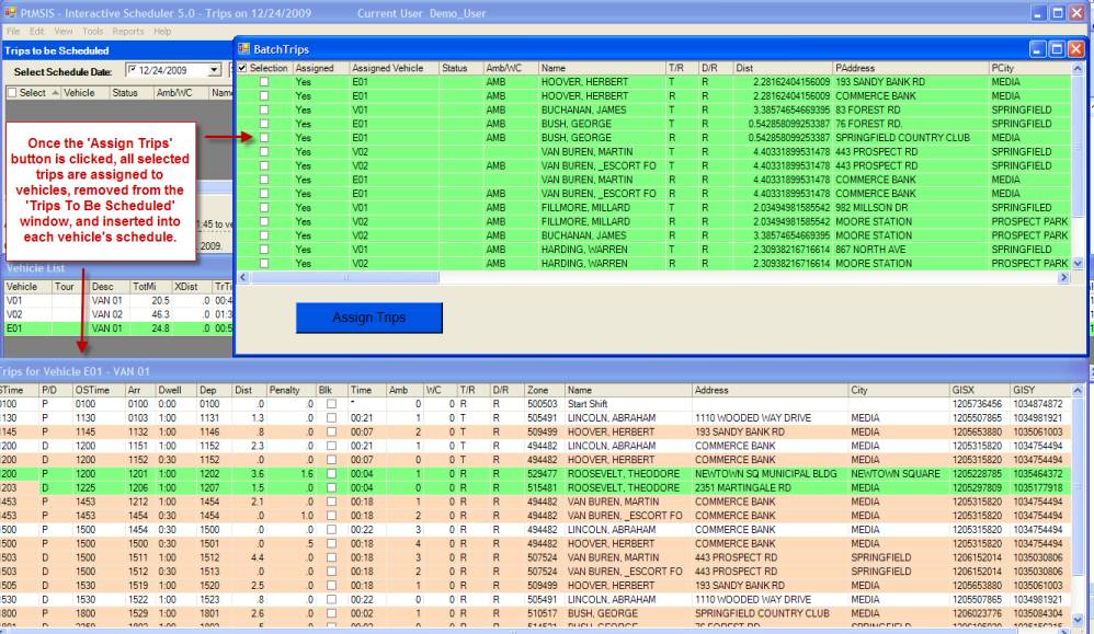
Assign Trips to Vehicle Schedules
Once the batch results
window displays, the user can select all or some of the trips listed in the
batch results window and insert the trips into the assigned vehicle’s
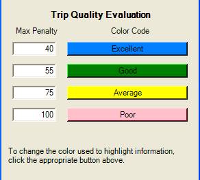
schedule. This step tests each
assignment to insure that the vehicle assignment meets the requirement of being
either an “excellent” or “good” vehicle assignment according to the schedule
fit point system (see Help/Color Codes).
Users can adjust the penalty point value that qualifies as Excellent or
Good trip assignments.
Select the trips to assign
to the vehicle schedules then click on the Assign Trips button to make the
assignments.
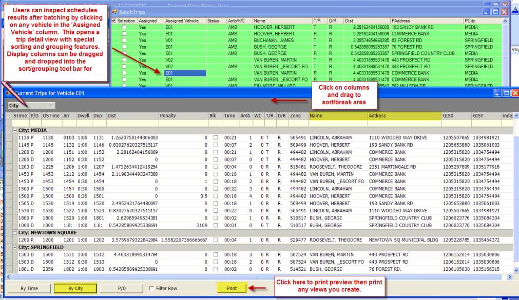
Assigned Vehicles Trip Detail View
Click on a vehicle in the ‘Assigned
Vehicle’ column and this will allow the user to open a trip detail view for the
selected vehicle. This view has special
interactive drag and drop sorting features that allow the users to examine the
schedule in unique ways.
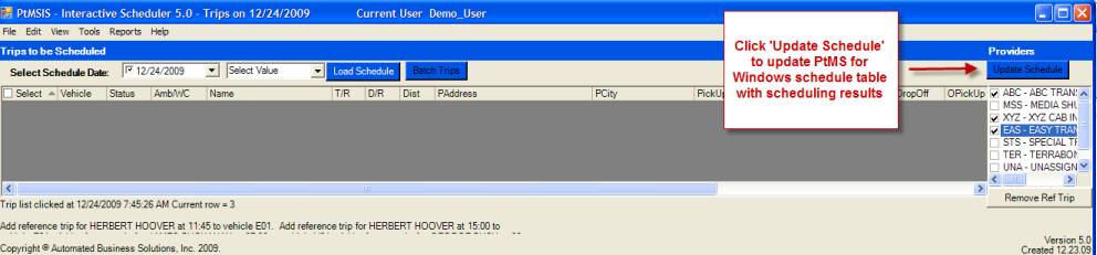
Update PtMS Schedule
PtMSIS 5.0 like any good
modeling system allows the users to perform “what if” analysis. The above batch process has not updated the
PtMS SQL database schedule table with the scheduling results until the user
selects the “Update Schedule” button in the top right hand corner of
PtMSIS. This means the user can try
different approaches to using the batch scheduling feature without actually
changing any of their live data until they have arrived at an approach
(scheduling all trips in one batch, or dividing the trips to be scheduled into
smaller batches) that works best for them.
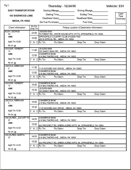
Print Your Schedule
Once a schedule is completed
the scheduler can print a driver’s Vehicle Manifest Report or schedule listing
Dispatchers report summarizing a days schedule in easy to read format.
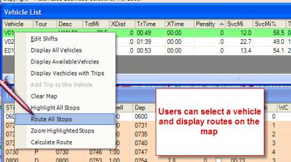
Map Your Route
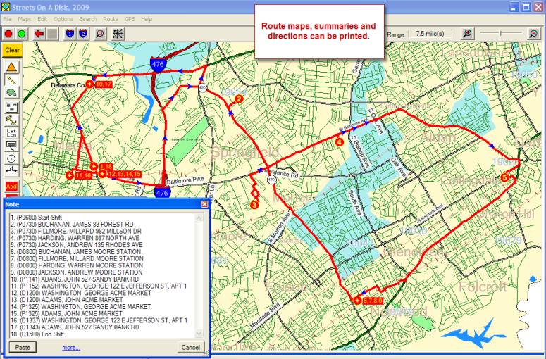
Visit Time: 0 hr(s), 4.00
min. (= 0.067 hrs)
Fuel: 8 mi/gal
Cost: $0.75 per mile(s)
--------------------------
Start: 1. (P0600) Start
Shift
--------------------------
Go southwest, 12 ft, on
Turn left, go southeast, 521 ft, on State Rte 252.
Slight turn left, go east, 1.0 mile(s), on
Turn left, go north, 1.1 mile(s), on Interstate Hwy
476.
Turn right, go northeast, 0.7 mile(s), on
Continue, go east, 0.5 mile(s), on State Rte 420.
Turn left, go northeast, 0.2 mile(s), on
Turn left, go northwest, 295 ft, on
Hard turn right, go east, 208 ft, on
--------------------------
Stop: 2. (P0730) BUCHANAN,
JAMES 83 FOREST RD
Time (from start): 0 hr(s), 5.08 min. (=
0.085 hrs)
Distance(from
start): 3.7 mile(s)
Clock (depart): 11:24 PM
--------------------------
Go west, 208 ft, on
Hard turn left, go southeast, 295 ft, on
Turn right, go southwest, 0.2 mile(s), on
Turn left, go southeast, 1.0 mile(s), on State Rte 420.
Turn right, go southwest, 0.3 mile(s), on Baltimore Pike.
Turn left, go southeast, 0.2 mile(s), on
Turn right, go southwest, 332 ft, on
Turn left, go southeast, 0.2 mile(s), on
Turn right, go southwest, 357 ft, on
Turn left, go southeast, 170 ft, on
Continue, go southeast, 0.1 mile(s), on Millison Dr.
--------------------------
Stop: 3. (P0730) FILLMORE,
MILLARD 982 MILLSON DR
Time (from last stop): 0 hr(s), 3.47 min.
(= 0.058 hrs)
Time (from start): 0 hr(s), 12.55 min. (=
0.209 hrs)
Distance(from last
stop): 2.2 mile(s)
Distance(from
start): 5.8 mile(s)
Clock (depart): 11:32 PM
--------------------------
Go northeast, 0.1 mile(s), on
Continue, go northwest, 0.2 mile(s), on
Turn left, go northwest, 292 ft, on
Turn right, go northeast, 332 ft, on
Turn left, go northwest, 0.2 mile(s), on
Turn right, go northeast, 1.4 mile(s), on Baltimore Pike.
Turn right, go southeast, 0.1 mile(s), on
--------------------------
Stop: 4. (P0730) HARDING,
Time (from last stop): 0 hr(s), 3.28 min.
(= 0.055 hrs)
Time (from start): 0 hr(s), 19.83 min. (=
0.330 hrs)
Distance(from last
stop): 2.1 mile(s)
Distance(from
start): 8.0 mile(s)
Clock (depart): 11:39 PM
--------------------------
Go northwest, 0.1 mile(s), on
Turn right, go northeast, 0.2 mile(s), on Baltimore Pike.
Continue, go northeast, 0.8 mile(s), on
Slight turn right, go east, 1.9 mile(s), on
Turn right, go south, 363 ft, on US Hwy 13.
Slight turn right, go southwest, 0.3
mile(s), on
Turn
left, go southeast, 299 ft,
on
--------------------------
Stop: 5. (P0730) JACKSON,
ANDREW 135
Time (from last stop): 0 hr(s), 4.69 min.
(= 0.078 hrs)
Time (from start): 0 hr(s), 28.51 min. (=
0.475 hrs)
Distance(from last
stop): 3.4 mile(s)
Distance(from
start): 11.4 mile(s)
Clock (depart): 11:48 PM
--------------------------
Go southeast, 158 ft, on
Turn left, go northeast, 0.1 mile(s), on
Turn right, go southeast, 429 ft, on
Slight turn right, go south, 2.2 mile(s), on US Hwy 13.
Slight turn right, go west, 0.3 mile(s), on
Turn left, go southeast, 122 ft, on
Turn right, go southwest, 391 ft, on
Turn right, go northwest, 0.1 mile(s), on
Turn left, go southwest, 0.3 mile(s), on
Slight turn left, go south, 327 ft, on
Slight turn right, go southwest, 182 ft, on
--------------------------
Stop: 6. (D0800) BUCHANAN,
JAMES MOORE STATION
Stop: 7. (D0800) FILLMORE,
MILLARD
Stop: 8. (D0800) HARDING,
WARREN MOORE STATION
Stop: 9. (D0800) JACKSON,
ANDREW MOORE STATION
Time (from last stop): 0 hr(s), 4.71 min.
(= 0.078 hrs)
Time (from start): 0 hr(s), 37.22 min. (=
0.620 hrs)
Distance(from last
stop): 3.4 mile(s)
Distance(from
start): 14.8 mile(s)
Clock (depart): 11:56 PM
--------------------------
Go northeast, 182 ft, on
Slight turn left, go north, 327 ft, on
Hard turn left, go southwest, 0.1 mile(s), on
Turn right, go northwest, 3.9 mile(s), on State Rte 420.
Turn right, go north, 0.3 mile(s), on State Rte 320.
Hard turn left, go southwest, 1.6 mile(s), on US Hwy 1.
Slight turn left, go southwest, 0.2 mile(s), on
--------------------------
Stop: 10. (P1141) ADAMS,
JOHN 527
Time (from last stop): 0 hr(s), 8.15 min.
(= 0.136 hrs)
Time (from start): 0 hr(s), 49.38 min. (=
0.823 hrs)
Distance(from last
stop): 6.2 mile(s)
Distance(from
start): 21.0 mile(s)
Clock (depart): 12:08 AM
--------------------------
Go southwest, 0.4 mile(s), on
Slight turn left, go southeast, 0.4 mile(s), on State Rte 252.
Slight turn right, go south, 0.5 mile(s), on
Turn right, go west, 281 ft, on
Turn left, go south, 492 ft, on Gayley St.
Turn right, go west, 85 ft, on
--------------------------
Stop: 11. (P1152)
WASHINGTON, GEORGE 122 E
Time (from last stop): 0 hr(s), 2.73 min.
(= 0.046 hrs)
Time (from start): 0 hr(s), 56.11 min. (=
0.935 hrs)
Distance(from last
stop): 1.5 mile(s)
Distance(from
start): 22.5 mile(s)
Clock (depart): 12:15 AM
--------------------------
Go east, 85 ft, on
Turn left, go north, 492 ft, on
Turn right, go east, 0.4 mile(s), on
--------------------------
Stop: 12. (D1200)
WASHINGTON, GEORGE ACME MARKET
Stop: 13. (D1200) ADAMS,
JOHN ACME MARKET
Stop: 14. (P1325)
WASHINGTON, GEORGE ACME MARKET
Stop: 15. (P1325) ADAMS,
JOHN ACME MARKET
Time (from last stop): 0 hr(s), 0.80 min.
(= 0.013 hrs)
Time (from start): 1 hr(s), 0.91 min. (=
1.015 hrs)
Distance(from last
stop): 0.5 mile(s)
Distance(from
start): 23.0 mile(s)
Clock (depart): 12:20 AM
--------------------------
Go west, 0.4 mile(s), on
Turn left, go south, 492 ft, on Gayley St.
Turn right, go west, 85 ft, on
--------------------------
Stop: 16. (D1337) WASHINGTON,
GEORGE 122 E
Time (from last stop): 0 hr(s), 0.80 min.
(= 0.013 hrs)
Time (from start): 1 hr(s), 5.71 min. (=
1.095 hrs)
Distance(from last
stop): 0.5 mile(s)
Distance(from
start): 23.6 mile(s)
Clock (depart): 12:25 AM
--------------------------
Go east, 85 ft, on
Turn left, go north, 492 ft, on
Turn right, go east, 281 ft, on
Turn left, go north, 0.5 mile(s), on
Slight turn left, go northwest, 0.4 mile(s), on State Rte 252.
Slight turn right, go north, 0.4 mile(s), on
--------------------------
Stop: 17. (D1343) ADAMS,
JOHN 527
Time (from last stop): 0 hr(s), 2.73 min.
(= 0.046 hrs)
Time (from start): 1 hr(s), 12.44 min. (=
1.207 hrs)
Distance(from last
stop): 1.5 mile(s)
Distance(from
start): 25.1 mile(s)
Clock (depart): 12:31 AM
--------------------------
Go southwest, 0.4 mile(s), on
Slight turn left, go southeast, 0.9 mile(s), on State Rte 252.
Turn left, go northeast, 12 ft, on
--------------------------
Stop: 18. (D1500) End Shift
Time (from last stop): 0 hr(s), 2.09 min.
(= 0.035 hrs)
Time (from start): 1 hr(s), 18.53 min. (=
1.309 hrs)
Distance(from last
stop): 1.3 mile(s)
Distance(from
start): 26.4 mile(s)
-----
Total Distance: 26.4 mile(s)
Total Drive Time: 0 hr(s),
38.53 min. (= 0.642 hrs)
Total Visit Time: 0 hr(s),
40.00 min. (= 0.667 hrs)
Total Time: 1 hr(s), 18.53
min. (= 1.309 hrs)
Total Fuel Usage: 3.31
gallons = 12.51 liters
Cost: $19.83
-----